
July 2023 Vol. 78 No. 7
Features
Achieving more accurate utility infrastructure mapping with the help of an app
(UI) — More than 217,000 utility damage events were reported in 2021, according to the latest Common Ground Alliance (CGA) DIRT (Damage Information Reporting Tool) Report. The three leading causes of these reported utility strikes were: digging without calling 811, failure to pothole and/or maintain clearance, and locating issues due to incorrect and/or outdated maps.
Steve Sellenriek, owner of Sellenriek Construction, Sellenriek Energy and UtiliSource, sits on the board of CGA. According to him, the association estimates that these events have an annual $90-billion impact on the U.S. economy.
“As an organization, a lot of our efforts go toward educating the general public and contractors about the dangers of digging without calling in locates first. However, with today’s technology, the industry can do much more to reduce utility strikes in the future,” he explained.
Sellenriek and UtiliSource President Josh Hinrichs estimated that the construction industry could save around $45 million annually if a living map of underground infrastructure was created and updated in the same fashion as navigation Apps used on smartphones today.
In the past, utility infrastructure mapping was nearly impossible for the industry because the technology to accurately locate, record and share the data did not exist. However, many new utility locators are now equipped with GPS capabilities that use global navigation satellite system (GNSS) and real-time kinematic positioning (RTK) services for pinpoint accuracy. According to Sellenriek and Hinrichs, when paired with the right data-capturing tool, this technology will make dynamic utility infrastructure mapping possible in the very near future.
Mapping utility infrastructure today
“The spatial accuracy of underground mapping needs to be precise,” explained Hinrichs.
Unfortunately, the industry is currently providing only general mapping. Sometimes, a person is lucky if a line is drawn on the correct side of the street. Historically, there hasn’t been a push for precision because it was too challenging, and no one was sure who was responsible for creating it. Therefore, the idea of live underground infrastructure mapping continues to be pushed to an unknown future date.
“However, our organization has taken it upon itself to pioneer more accurate and up-to-date mapping technology,” he said. “With all the advances in GPS technology, high-speed internet on smartphones and software programming, we believe we can achieve the necessary precision in underground mapping currently lacking in the industry.”
The Sellenriek businesses is the perfect team to take on this enormous task because they have people in the field performing every step of the utility construction process. The group is based out of Jonesburg, Mo., but you can find its people working throughout the U.S.
UtiliSource provides a range of services, such as fiber network engineering and design, damage prevention, mapping, subsurface utility engineering (SUE) and geographic information system (GIS) services. The UtiliSource field team works with utility companies to locate underground facilities and inspect construction work, making them the ideal group to support and create accurate utility infrastructure mapping.
Sellenriek Construction Inc. was founded by Bob Sellenriek, Steve’s father, in 1979. The company initially worked for the local telephone company, using a backhoe and trencher to perform installs. Since then, the company has helped pioneer the horizontal directional drilling (HDD) industry while also performing open-cut services and expanding into aerial work.
In recent years, the company has split into two divisions. Sellenriek Construction focuses on installing broadband, while Sellenriek Energy specializes in electrical distribution work, gas pipelines and civil boring projects.
Sellenriek Construction employs over 30 HDD crews, four aerial teams and several crews that use vibratory plows to install fiber in rural areas. The team also manages up to 30 subcontractors during busy seasons.
By contractors, for contractors
UtiliSource and Sellenriek Construction are involved in virtually every aspect of the utility construction process and the ongoing care of utility infrastructure. This gives their teams a unique perspective on how to best protect what’s in the ground today and create a better mapping system for the future. Sellenriek and Hinrichs put this perspective into action.
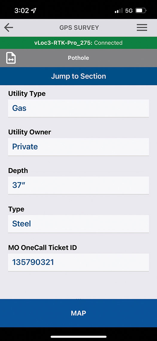
FieldSource is a powerful open-source software platform developed with the help of the utility coordination group at UtiliSource. The platform’s operator interface is an easy-to-use App for Apple and Android smartphones. It uses data from RTK-capable utility locators to capture more accurate utility coordinates.
However, its data capture services go beyond that. For example, Sellenriek Construction’s potholing and HDD crews use FieldSource to capture data points during each phase of their projects.
“After the locates are done, our teams will pothole nearby utilities,” explained Sellenriek. “During this process, they mark the locations of buried lines they find and input information about the type of utility, its owner, and its depth and diameter. They can also use the FieldSource App to upload photos of important landmarks and exposed utilities.”
Moreover, the installation crew can utilize data from the HDD locating system or GPS-enabled smartphones to provide precise as-built information.
“As an organization with numerous teams installing utilities daily, we realize that not every line is installed using HDD, which makes it more challenging to gather as-built data points. There is no guidance system on a shovel. With FieldSource, users can combine location coordinates from multiple sources to create a more comprehensive mapping system,” Sellenriek explained.
After collecting the data, it is uploaded to the Cloud, making it shareable for everyone involved in the project. The team that developed FieldSource hopes to make this information available to all utility owners, locating services and contractors performing future work in the area. That is why the team decided to use an open-source platform to build it. Data uploaded from FieldSource can be used with other software programs.
Sellenriek Construction and the UtiliSource team have tested FieldSource in their daily operations for over two years. According to Hinrichs, “Our teams have been responsible for beta testing FieldSource and have regularly given us feedback so that we can make the App as intuitive as possible.
“We don’t want FieldSource to be an extra step in their process; we want it to help them do their job more efficiently, while collecting mapping details that can help everyone avoid utility strikes in the future. With where we are today with FieldSource, I know we’ve accomplished that goal.”
FieldSource has reduced the amount of time Sellenriek Construction supervisors spend on paperwork from 35 minutes daily to an average of 5 minutes. As a result, their crews have been able to increase their average operating time.
“It doesn’t matter what equipment we’re using; they can only operate so fast each day. The key is to ensure they’re not standing still, waiting for locates or damage assessment after a utility strike. Access to more accurate mapping data can help crews optimize their time on the job. FieldSource won’t make a drill more productive, but it will help keep crews drilling,” Sellenriek explained.
Implementing FieldSource has significantly reduced the number of near misses and utility strikes for Sellenriek Construction’s crews.
“For the past two years, more than 40 of our crews have used FieldSource, and we have not had any at-fault events,” reported Sellenriek. “FieldSource allows us to more accurately document our work so we can demonstrate to utilities and municipalities that we took all the proper steps throughout our part of a project.”
Collecting data
UtiliSource developed FieldSource as a resource for utility owners, municipalities, engineering companies, locating services and contractors performing installation work. More accurate data and detailed information benefit everyone in various stages, from planning to execution.
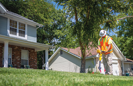
“Our utility locators use FieldSource every day when they mark utilities, and the information collected helps save them time when they are called out to do a locate in that area again,” said Hinrichs.
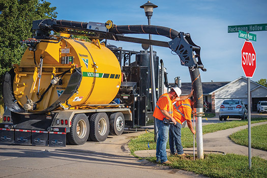
Before conducting HDD and plow work, Sellenriek Construction deploys vacuum excavator crews to locate nearby utilities by potholing. The company has over 14 trailer vacs in its fleet for this purpose. However, Sellenriek is also optimizing the process.
“In the last year, we’ve added a Vermeer VXT300 and a VXT600 truck vacuum to our fleet, and they have outperformed our trailer vacuums. Each one can do the work of three to four trailer vacuums with the same number of people,” he said.
The production output from Vermeer truck vacs, combined with the data collected using the FieldSource App, provides installation crews with everything they need to maximize productivity on a daily basis. These teams also collect data points throughout the process so that as-built information can be quickly delivered to utility owners.
With accurate data collected, utility owners have precise information to share with others the next time work is being done in an area.
Collecting more underground data using accurate tools and technology is crucial for creating a living utility infrastructure map. This will help reduce the number of utility strikes in the future. FieldSource is an important tool that can help the industry achieve this goal.
FOR MORE INFORMATION:
Sellenriek Construction, (573) 474-2065, sellenriekconstruction.com
UtiliSource, (636) 488-6195, utilisource.us

Comments