
November 2019 Vol. 74 No. 11
Features
Harnessing Better Data to Embrace Defensive Digging
Latest GPR Innovations Provide Contractors Line of Defense Before Breaking Ground
Michael Bateman
Data is everywhere – even buried in soil. It’s no longer just a Silicon Valley buzzword, but rather something tangible that contractors working in underground infrastructure installation and maintenance can harness for safer and more efficient operations.
Contractors often face the common challenge of having to navigate unchecked and unmapped infrastructure beneath soil. This makes preparing for a new dig especially time-consuming. Rather than having data that could notify workers to the presence of buried objects before digging, there is often a very laborious prepping process that requires locating subsurface objects before breaking ground. Without such data, the contracting team gets lucky and breaks through undisturbed soil, at best. At worst, the consequences could be costly and dangerous.
However, now the underground infrastructure industry can further embrace the use of deliverable data when preparing for new digs. Having a deliverable in place that can serve as a common reference point for all on the job site will create a more efficient and safer work environment for everyone involved. Similar to the term “defensive driving,” this concept of “defensive digging” is where having full awareness of all buried infrastructure on or near a job site can exponentially reduce the risk of damage.
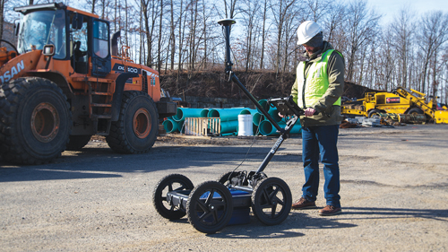
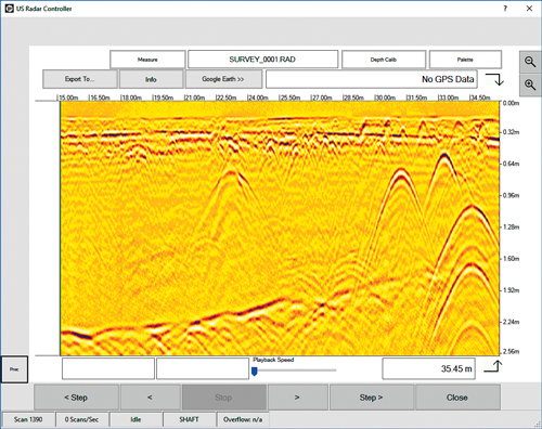
One technology, in particular, ground penetrating radar (GPR), can best assist underground construction contractors in compiling such useful data. Thanks to GPR’s ability to penetrate all soil conditions and detect all material compositions of buried objects, there is no shortage of data collection possibilities.
It should be noted that not all GPR systems are created equally. To maximize return on investment, the operator needs to use a high-quality system that comes with multi-frequency signal output, self-calibrating antennas, and advanced data processing and post-processing features.
Here are some ways that GPR can assist contractors before conducting an installation or maintenance project.
Creating deliverable data
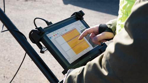
More than a locating tool, sophisticated GPR systems double as data collection platforms. As the operator moves the antenna along the soil surface, multiple frequencies emitted by the system are transmitted back, creating datasets that can be saved, reviewed and post-processed later. This can be done both before and after a job has been completed.
The data that these GPR systems compile gives contractors a clear picture of any existing buried infrastructure, miscellaneous objects or soil conditions that could play key roles in the outcome of the project. This information can then be saved and shared digitally to provide a common point-of-reference for any interested party on or off-site.
Navigating soil conditions
Breaking ground is nothing new for underground construction, but the conditions of the job-site soil can make a huge difference when acquiring data for defensive digging. The dielectric properties of the soil directly impact a locating device’s ability to get a clear read of what’s beneath the surface. Common soil conditions that can affect locating tools include the soil’s material composition, moisture content and density. For example, a dense, wet clay soil is often more difficult for most tools to scan through than clean and dry sand.
Well-made GPR systems have a way to get around this common obstacle. A high-quality antenna should be able to auto-calibrate itself to prevailing soil conditions. This means less loss of signal, which leads to a clearer set of data to reference.
Doing what other locating tools cannot
Most traditional locating devices are designed to only detect a specific type of material or only scan to a certain, often shallow, depth. When preparing for trenching, directional drilling or maintaining existing infrastructure, not all tools will be effective. This is especially true when locating non-conductive objects. A device manufactured specifically for detecting metal pipe won’t be able to reveal if there is also clay pipe, poly lines or fiber optic cables alongside.
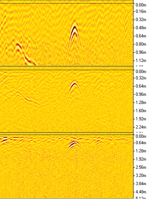
Using GPR, however, the operator can locate all conductive and non-conductive objects. Each one is displayed as an arch-shaped hyperbola on the screen. The narrower and sharper the hyperbola, the smaller the object. A high, slim arch is more likely to be cable, whereas a broader arch could be something similar to a buried septic tank.
More efficient digging environment
Like hydro or vacuum excavation systems, sophisticated GPR systems do not require digging or a complex setup process. You only have to connect a battery, activate the software, calibrate the antenna and start scanning. This creates a more efficient environment, where the locating team can gather high-quality data without having to engage in large-scale setup or teardown. All you need to generate effective results is some minor, low-intensity training and your field knowledge.
Mapping for future defensive digging
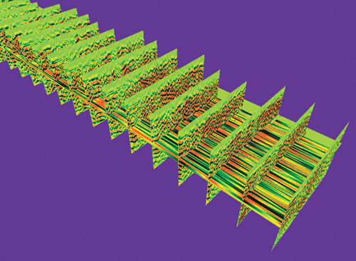
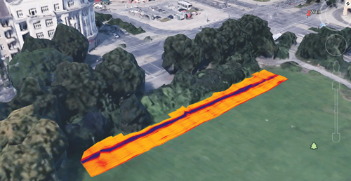
With the right GPR system, the operator can post-process the scan data into sharp, dynamic visual representations. Whether that is creating a 3D model or mapping findings on a GPS-integrated application, the data can translate into a format that allows for easier understanding and more actionable decision-making.
Should the contracting team ever have to return to that same site for maintenance or new installation, there is a common reference point that all team members can implement for safer and more efficient operations. This cuts down prep time and eliminates uncertainty by informing the team where buried objects are located before any ground is broken.
Data is everywhere. Using the right subsurface locating system, it can be used to help protect and prosper underground construction professionals. It’s time to start harnessing it more effectively to maximize efficiency and reduce risk. •
For More Information:
US Radar Inc., (732) 566-2035, usradar.com

Comments