
December 2019 Vol. 74 No. 12
New Products
First Look: DCA Unveils Terrain Mapping Tool
Digital Control Inc. (DCI) has unveiled a new terrain mapping tool that includes a real-time bore planner for the horizontal directional drilling (HDD) industry. This is the first of several products to be introduced for DCI’s new earth mapping product family, TeraTrak.
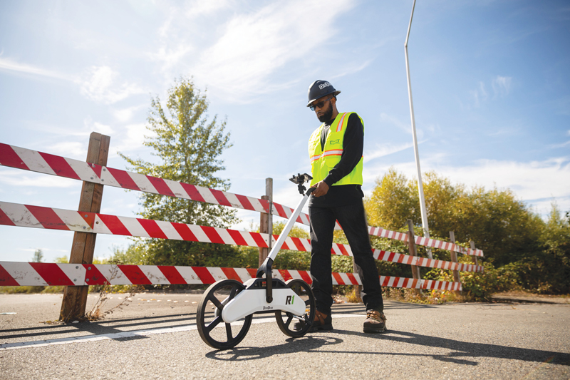
The TeraTrak R1 was first shown to the public at the 2019 ICUEE show and is scheduled to be available in early 2020, said Siggi Finnsson, longtime DCI product manager.
“The R1 is a new dimension for terrain mapping and job-site data collection,” said Finnsson. “A consistent issue in HDD is that inadequate terrain information makes drilling decisions difficult. The R1 provides terrain and distance data in a fast and easy manner to solve these problems. Anyone on the crew can now create a comprehensive overview of the job site, including existing utilities and other potential hazards.”
Benefits include faster bores, greater cost savings, fewer re-drills and fewer bent rods, Finnsson added.
Drill Calc, a function in the TeraTrak R1 app, allows the user to enter desired or current depth and pitch to quickly generate a rod-by-rod plan. In a matter of minutes, the user can perform a rig setback calculation or determine the correct rod-by-rod plan to hit a target at a critical juncture or simply make adjustments for terrain challenges. Upon first release, the TeraTrak app will be limited to a maximum 75 feet for rod-by-rod plans with increased capabilities through future app updates.
Experience
DCI has leveraged its 30 years of market experience with DigiTrak products in the design and capabilities of the R1, Finnsson said.
“The R1 is designed to track straight and handle rough terrain. With an accuracy of plus/minus 6 inches over 500 feet, it provides the level of accuracy needed for horizontal directional drilling,” he said. “The R1 fits in a 36- by 18-inch case for easy transport and weights14 pounds. As with all DCI products, the R1 is rugged, reliable and built to handle harsh environments.”
For the bore plan, typically the user enters previously obtained information on existing utilities. Using DCI’s patent-pending algorithm technology, the R1 maps distance and elevation. Locations of existing utilities also can be entered after the R1 maps terrain.
Terrain data from the R1 is streamed in real-time via Bluetooth to the user’s mobile device which mounts on the R1 handle. This data can also be exported for use in other bore planning software.
“The R1 was developed to solve real challenges in HDD and builds on DCI’s vision of integrated products to boost productivity, usability and safety,” Finnsson said. •
FOR MORE INFORMATION:
Digital Control Inc., (800) 288-3610, digital-control.com

Comments