
February 2019 Vol. 74 No. 2
Rehab Technology
Identifying and Classifying a True Miscellaneous Water Level Sag

By NASSCO Member Michael P. Kerr, NASSCO Training Director
When coding pipe conditions using the Pipeline Assessment Certification Program (PACP®), a well-meaning operator may view a change in water level and call out a Miscellaneous Water Level Sag (MWLS) in the line. This NASSCO Tech Tip is provided to assist in identifying a true Sag from other conditions—such as increased flow—that would cause a change in water levels.
During an inspection an operator should be diligent in considering other possible causes of water level changes before coding MWLS. For example, while water levels may appear to increase, the effect could actually be caused by something under the water such as debris or obstructions. Below are some personal observations and tips from the field that will provide insight into proper classification of these conditions.
As the camera travels down the pipe it should be centered at the 50% cross-section location. If the operator observes that the water level has increased to 60% or more, and the camera lens does not have water appearing on the lens, it is quite likely the camera may be driving on a deposit or other obstruction underneath the water.
For example, I once reviewed an inspection that had a water level of 80% and was therefore listed as a Sag. The problem with this report is that I did not see any water on the lens and the camera was high in the pipe. It was my determination that the water level was not due to a Sag, but rather from unseen debris or obstructions under the water.
There are three very important elements of a Sag:
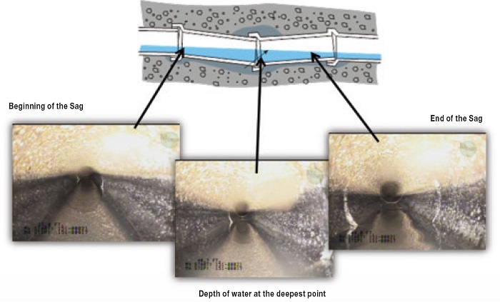
#1 – Beginning of the Sag
#2 – Depth of water at the deepest point
#3 - End of the Sag (if it is a Continuous Defect)
Note: If a Sag is not a Continuous Defect (less than 3 feet in length), the Sag is coded at the deepest point, with the ending footage recorded in the Remarks column.
It is extremely important to clearly code the location where the water level returns to normal at the end of the Sag. If not, it may just be an increase in the water level from laterals or infiltration.
Another tip: When recording the percentage of cross-sectional area lost due to debris or an increase in water level, if is often easier and more accurate to take the photo near a joint, as this provides a more definitive point of reference. This can also help to ensure correct clock positions are incorporated with the percent of the cross-section. If an obstruction takes up 30% of the cross-section in the bottom of the pipe, using 4 to 8 as clock positions would be appropriate (not 5 to 7, which would indicate a lower percentage of approximately 10- to 15-percent).
Tech Tips by NASSCO is a bi-monthly article on trends, best practices and industry advice from NASSCO’s Trenchless Technology membership professionals.

Comments